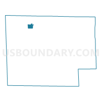
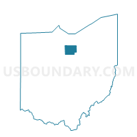
MONROEVILLE VILLAGE, Huron County, Ohio
About
Outline

Summary
| Unique Area Identifier | 648048 |
| Name | MONROEVILLE VILLAGE |
| County | Huron County |
| State | Ohio |
| Area (square miles) | 1.43 |
| Land Area (square miles) | 1.40 |
| Water Area (square miles) | 0.03 |
| % of Land Area | 97.88 |
| % of Water Area | 2.12 |
| Latitude of the Internal Point | 41.24384350 |
| Longtitude of the Internal Point | -82.70257540 |
Maps

Graphs
Select a template below for downloading or customizing gragh for MONROEVILLE VILLAGE, Huron County, Ohio